top of page

Search

Jan 27, 20233 min read
Accuracy of Stockpile Volumes from Drone images | Hammer Missions
In this study, we look at how accurate are the stockpile volume calculations from drone images, 3D models and hammer missions.

Jan 18, 20232 min read
How To Use The Mavic 3E with Hammer Missions
Steps on using DJI Mavic 3 Enterprise (M3E) drone with Hammer Missions.


Jan 12, 20233 min read
Safety In Vertical Drone Flights | Hammer Missions
Vertical drone flights can be a nerve-wracking experience but if done correctly with all safety aspects and mitigation taken into account.

Dec 22, 20224 min read
Site Planning Tools | Hammer Missions
How to use site planning tools (point of interest, ruler, area) in Hammer Missions

Dec 21, 20222 min read
Accuracy of Measurements in Drone 3D Models | Hammer Missions
In this article, we understand the accuracy of 3D measurements using drone 3D models when compared to real world measurements.

Dec 9, 20223 min read
Automatic PDF Reports | Hammer Missions
How to automatically create PDF reports from drone mapping & inspection data using Hammer Missions.

Nov 15, 20222 min read
Volumetric Measurements with Drone Data | Hammer Missions
In this article, we look at how to conduct Volumetric Measurements on Drone 3D models.


Nov 14, 20224 min read
Drone Mapping vs Drone Inspections | What's The Difference Anyway?
Drone Mapping vs Drone Inspection - What's the difference and when to use which? We answer the question in this post.

Nov 8, 20223 min read
How to 3D Map and Inspect a Building in the same project | Hammer Missions
This post explains how to 3D map and inspect a building in the same project using Hammer Hub, by Hammer Missions.


Nov 3, 20223 min read
How to install Hammer Missions on the DJI Smart Controller
In this guide, we will walk you through how to install Hammer Missions App on the DJI Smart Controller for DJI's Enterprise Drones.

Nov 1, 20223 min read
Using Measurements in Hammer Missions | Drone Mapping
A step-by-step tutorial on how to make measurements (distances, areas, volumetric) using drone imagery and 3D models.

Oct 24, 20226 min read
Improving the Quality of your Drone Maps and 3D Models
In this post, we explore how you can greatly improve the quality of your drone maps and 3D models by focusing on key data capture workflows.

Oct 2, 20223 min read
Annotating Drone Data in Hammer Missions
In this article, we will look at how to annotate drone data for surveys and inspections using Hammer Hub.


Sep 27, 20225 min read
Drone Programs: Top 5 Considerations
Starting Enterprise Drone Programs can be challenging. In this article, we look at the top 5 considerations for starting UAS programs.

Sep 22, 20222 min read
How To Use Unsupported Drones with Hammer Missions
How to use unsupported drones with Hammer Missions.


Sep 22, 20224 min read
Drone PPK - How does it work?
In this article, we look at how drone PPK works and how Hammer Missions can be used to create RINEX files for drone PPK workflows.
Sep 19, 20225 min read
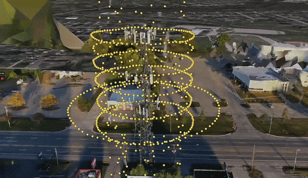
Drone Cell Tower Inspections: Step-by-Step Guide
Drone Cell Tower Inspections - a step-by-step guide from data capture to data processing. Sharing 3D models, digital twins, PDFs and more.
Sep 6, 20226 min read
Drone Facade Mapping & Inspection - A step-by-step guide.
A guide to drone facade mapping and inspection using DJI drones and Hammer Missions.

Aug 22, 20221 min read
3-Steps to Activate Your Enterprise Teams Account
In this guide, we look at how to activate your enterprise teams account, when invited by an enterprise admin.


Aug 9, 202212 min read
How to Use Drones for Building Inspections
In this article, we're going to look at how you can use Hammer Missions and other tools to perform an end-to-end building inspection.

Jul 19, 20225 min read
Flight Planning For Unlocking DJI Drones In No Fly Zones
In this guide, we will establish how to unlock DJI Drones to enable flight planning in pre-defined Geo-restricted zones, using DJI Flysafe.


Jul 9, 20222 min read
What are Flight Lines and Tie Lines in Magnetic Drone Surveys
Picture courtesy of SkyFront Overview In this article, we will discuss flight lines and tie lines and how they are relevant in drone...


Jul 8, 20224 min read
Desktop vs Cloud Drone Software
In this article, we will look at the key considerations to bear in mind while choosing between desktop vs cloud drone software.


Jun 23, 20223 min read
How to Decide Flight Altitude for Drone Mapping and Inspection?
In this short article, we will discuss how to decide flight altitude for drone mapping and inspection.
bottom of page