
How to capture high-quality 3D models using drones? Best Flight Plans
- Hammer Missions
- Aug 20, 2024
- 3 min read
Updated: Oct 6, 2024
Overview
Capturing 3D models with drones is both an art and science. Not only do you have to plan the best flight plan for your drone for efficiency, but also to capture images in the right places to process 3D models and capture all the required details. But the built world is complex, how do you ensure that you are capturing the right data at all times? We'll take a look in this guide.
Photogrammetry
The first thing to understand while capturing images with drones, is that the main technique used to create 3D models with drones (as 2024) is called photogrammetry. In a nutshell, this technique uses the matching features between images to stitch together 2D maps and 3D models form drone images. Because the technique is so heavily reliant on matching features, it is really important that most of your drone images overlap with each other by at least 70% in every direction.

So with the overview and photogrammetry definitions out of the way, let's look at typical structures and how to best capture them.
1. Flat Sites: Construction Sites / Solar Parks, etc
The best way to capture relatively flat sites, such as construction sites, farms or solar parks is to simply use a single lawn mower pattern.
In Hammer Missions, this is called a 'Mapping Mission'


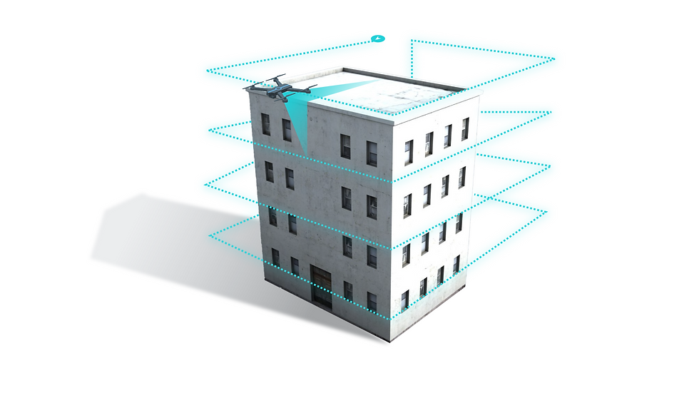
2. Single Short Building
The best way to capture a single short building is to divide the building into 2 groups of images: a group of images for the roof and a group of images for the facade. You can then fly a double grid lawn mower pattern on the top of the roof with a slight gimbal angle (-60 to -70 degrees) and a vertical orbit mission to capture the facades of the building.
In Hammer Missions, these are '3D Modelling' and 'Facade Mapping' Missions.

Make sure to capture both the roof and the facade in both flight plans!

3. Single Tall Building
For tall buildings, it might not be feasible to go around the building in orbits. If so, you can divide the building into 3 components - roof, 1 orbit, facades. You can then combine all the data into 1 project.
In Hammer Missions, these are '3D Modelling', 'Tower Mapping and 'Facade Mapping' Missions.

4. Industrial Site with many buildings
For industrial sites with many buildings of varying heights, the best capture method is to fly a double grid lawn mower pattern with a -70 degree gimbal angle or similar. If you'd like to model the facades of particular buildings, you can also add a vertical facade flight plan for specific buildings together with the overarching flight plan for the full site.
In Hammer Missions, these are '3D Modelling' and 'Facade Mapping' Missions.

5. Facades
If you are only interested in a particular facade of the building, then simply fly a vertical single grid flight path with a 0 degree gimbal angle in front of the building facade, it's that easy!
In Hammer Missions, is 'Facade Mapping'.

6. Towers
When it comes to towers, dome shaped buildings or smoke stacks, you can typically orbit around the tower to capture all the details, by either going left to right first and then up and down, or up and down first and then left to right. With towers, it's important to use a small gimbal angle (-70 to -85) to avoid horizon or sky in the images.
In Hammer Missions, is 'Tower Mapping'.

7. Bridges
Bridges can be captured similarly to buildings but if you are looking at a long linear structure, it might be worth using a double grid lawn mower pattern (3D modelling mission) in Hammer with a more aggressive gimbal angle (-60 degrees) and then flying the under deck using a vertical facade flight plan.
In Hammer Missions, these are '3D Modelling' and 'Facade Mapping' Missions.

Summary
In this guide, we explored various capture methods for flying drones to capture different types of structures. Hopefully, this information has helped you build a better understanding of how to approach aerial photography. Remember, nothing beats real-world experience, so get out there and start capturing some buildings!
About Us
Hammer Missions is an enterprise-grade software platform to create 2D maps, 3D models and AI-based inspection reports of built structures using drone images.
Improve decisions & win more projects using Hammer Missions.
Sign up for our trial or arrange a demo with one of our product specialists.