
What are Ground Control Points? Drone Mapping | Hammer Missions
- Hammer Missions
- Mar 21, 2023
- 4 min read
Updated: Dec 18, 2023

Image Credit: Heliguy
Overview
Often overlooked as part of the mapping and data collection process are GCPs (Ground Control Points). GCPs are a very important addition to the end-to-end flow of data collection.
So, what are GCP's and why are they important?
In this short post, we will discuss why you need GCPs and their place in improving the accuracy of your mapping missions.
What is a GCP?
GCPs are known points on the Earth's surface that are precisely located and used as reference points for geo-referencing satellite or aerial imagery, in our case, drone mapping.
These points are usually identified by a set of geographic coordinates (latitude, longitude, and elevation) and can be natural features such as rock outcroppings or man-made objects such as buildings or survey markers, as shown below.

GCP markers, as shown above, should be high contrast so they can easily been seen from the drones camera, or point of view if you like.
Some surveyors prefer to spray their GCP onto the ground using bright coloured paint, either way is acceptable as long as the GCP is visible from the air.
GCPs help deliver improved accuracy in drone mapping by defining a location with absolute accuracy.
Essentially GCPs, in their base form, help to the software, whether that be for photogrammetry or mapping, 'peg' the map on top of the base map more accurately using the known points that have been recorded. 🗺️ 📍
So, how do we record those points and where do we place the GCPs? Let's take a look.
GCP Placement & Measurement
Now we have established what a GCP is it is important to know where to place GCPs on your site to get the best positioning.
A GCP must be visible from the air and evenly located across the site, the amount of GCP's you require are dependent on the size of the site.
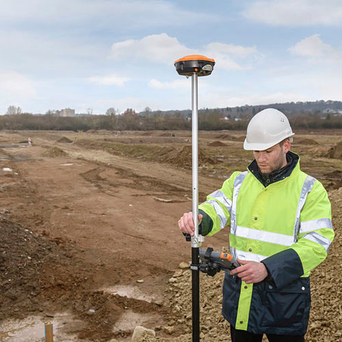
After placing a GCP, you will need to measure its position using a GNSS (Global Navigation Satellite System) RTK or PPK receiver and record its position.
This recorded position will help determine the accuracy when you come to process your drone map.
Image Credit: Heliguy
Using GCPs with Drone Images
So you have placed all your GCPs on your site, measured their position with a GNSS Receiver, and flown your mission, but how do you use them? What do they actually look like?
Once you have measured their position you will have a .CSV file stored in the GNSS receiver of all the known locations of the GCPs.
This data is typically uploaded alongside your captured data to determine the exact positioning.
The CSV file from the GNSS receiver will look something similar to the one below:

Image Credit: MDPI
This is the file that will need to be uploaded alongside the data.
Do you always need GCPs?
If you have a drone that already has RTK or PPK enabled, strictly speaking you do not need GCPs as the accuracy of the drone map or model will be enhanced using the built-in RTK feature. However, it's still a good practice to have GCPs to fallback on, in case you are unable to get RTK signal on a specific site.
Some examples of drones with RTK technology are:
To learn more about Hammer Missions and RTK and PPK have a look at our posts below:
In the video below, Alex and Varun from Hammer Missions discuss not only GCPs but RTK and PPK and how they operate.
Advantages & Disadvantages of GCPs
GCPs are great, but like everything else, they have their advantages and disadvantages.
So what are the advantages and disadvantages of GCPs?
Advantages
✅ GCPs will work with any drone.
✅ A good backup method of no RTK signal is available in the field.
Disadvantages
⚠️ Longer set-up times as GCPs have to be manually placed on site.
⚠️ Requires complete access to the site.
⚠️ The overall workflow could be substantially longer.
Summary
When it comes to collecting data for drone mapping or photogrammetry, accuracy is paramount and with the correct tools and software, like Hammer Missions, at your disposal, you can ensure that your data will be as accurate as possible time and time again.
RTK and PPK seem to be the future of accurate data collection on site but GCPs are still a good option when there is nothing else available as it will greatly improve the accuracy of your map or photogrammetry project.
We hope the article helps you understand why GCPs are important in drone mapping.
If you'd like to learn more about how to capture high-quality data and get the most out of your drone flights using our cloud-based platform, please feel free to visit our learning resources.
If you haven't got a Hammer account and would like to try Hammer Missions you can get started on our free trial.
To learn more about our enterprise solutions, including mission collaboration, data processing, and AI solutions, don't hesitate to get in touch with us at team@hammermissions.com.
We look forward to hearing from you.
— Team at Hammer Missions